
Media Room
|
: 12 : Admin : Fri, 25 August 2017, 12:00 AM |
| Smart Geospatial Expo 2017, a Peek into Future Spatial Information Trends |
|---|
|
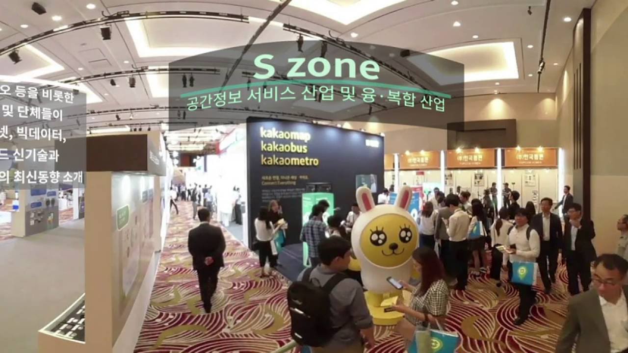
Smart Geospatial Expo 2017, a Peek into Future Spatial Information Trends Fifty-four exhibitors will participate in the Expo to be held from Aug. 30 to Sept. 1
_국토부%20이성해.jpg) Director General Lee Sung-hae of the Spatial Information Policy Bureau at the Ministry of Land, Infrastructure and Transport (MOLIT). The Smart Geospatial Expo 2017 will take place at the aT Center in Yangjae-dong, Seoul, from Aug. 30 to Sept. 1. The Expo, to be held under the general theme, “Spatial Information, the Guide to the 4th Industrial Revolution,” will serve as an opportunity to look at the latest spatial information technologies and future spatial information trends. A total of 54 company and institution exhibitors will participate in the Expo. They include all sorts of companies having spatial information technologies or those providing relevant services, including startups, measurement companies, internet portals and leisure and sports companies. The following are excerpts of an interview between NewsWorld and Director General Lee Sung-hae of the Spatial Information Policy Bureau at the Ministry of Land, Infrastructure and Transport (MOLIT) in which he spoke of the upcoming Smart Geospatial Expo 2017. Question: Will you introduce the Smart Geospatial Expo? Answer: The Smart Geospatial Expo is an annual festival of spatial information communities which drives the development of the spatial information industry, facilitates information exchange and gives a glimpse into the future of the industry. Hosted by the MOLIT, the Expo is organized by five institutions, namely the Korea Land & Housing Corporation, Korea Land and Geospatial Informatix Corporation, Korea Research Institute for Human Settlements, and Korean Association of Spatial information, Surveying & Mapping. It draws executives and staff of Korean and international spatial information companies, foreign government officials working on spatial information, industry experts and general visitors. The Smart Geospatial Expo 2017 is the 10th rendition of smart geospatial expo. The Expo made its debut in 2008 as a merger of the government’s spatial information events. Since then, the Expo has shared the significance and value of spatial information with people in tandem with the trends and calls of the time and successfully guided the way forward for the spatial information sector. Moreover, the Expo has served as an opportunity to reinforce the cooperative system with foreign high-ranking officials and experts in the area of spatial information, and grasp the trends of the global spatial information. Q: What exactly is spatial information? Please explain the value and significance of spatial information. A: Spatial information refers to locational information and attribute data of all objects around us. The locational information indicates where the object is, while the attribute data indicates what sort of properties the object has. Spatial information may sound like an unfamiliar term, but it is deeply embedded in our lives. For example, when you are out and about, you can find bus arrival time for the nearest bus stop, or search the location of subway trains to figure out the shortest travel distance. Also, you can locate restaurants or find suitable accommodation when traveling, all thanks to spatial information. Spatial information is highlighted as the key infrastructure in the age of the 4th Industrial Revolution as it drives innovate among conventional industries and creates new sectors by incorporating state-of-the-art technologies, such as sensor technologies (as in the case of autonomous vehicles, drones, etc.), as well as big data.
Dignitaries and spectators wear VR glasses during the Smart Geospatial Expo 2016. Q: Will you elaborate on key programs and highlights of the Smart Geospatial Expo 2017? A: The Smart Geospatial Expo 2017, to be held under the theme, “Spatial Information, the Guide to the 4th Industrial Revolution,” is characterized by its effort to communicate with people of all ages. In particular, its programs involve proactive participation, experience and educational resources to attract the interest of young people. In the 4,200妊 exhibition area, a total of 54 company and institution exhibitors will set up roughly 130 booths. The exhibitors include all sorts of companies having spatial information technologies or providing relevant services, from startups, measurement companies, internet portals to leisure and sports companies. The keynote speaker of the opening ceremony of this year’s Expo is Director Park Jong-hwan of Daum Kakao, who serves as president of “LOC & ALL,” a startup, which is well known for developing the GPS navigation “Kimgisa.” Furthermore, startups that received subsidies from the MOLIT, including Data King and E Flap, will participate in the Expo. The Experience Zone at the Expo venue is designed for general visitors to get more familiar with spatial information by providing opportunities to have a first-hand experience of spatial information involving all five senses. For example, the programs include a spatial information maze, a smart sand craft, PyeongChang Winter Olympics 2018 VR sports, and spatial information quiz contests. In addition, minister-level meetings, technical seminars and business meetings will be arranged to support Korean companies’ overseas expansion. Also, there will be cooperative meetings between participating countries, a “best practice” contest for the convergence of spatial information, as well as a job fair based on National Competency Standards and a smart safety guide contest for children.
A view of Kakao’s booth at the Smart Geospatial Expo 2016.
A view of a booth in which people experience a self-driving car at the Smart Geospatial Expo 2016. (Photos: MOLIT) Q: What is the direction of the way forward of the national spatial information industry? A: The MOLIT has continued to establish spatial information that can be incorporated into ICT, while simultaneously implementing supportive policies, such as continued disclosure of spatial information data, job creation, support for the exploration of new sectors, etc., in the belief that it is not only important to efficiently establish spatial information, but also to derive tangible results, such as driving the growth of the industry and creating new sectors. Recently, the ministry disclosed 57 types of spatial information, including digital and 3D maps, and will continue to expand the scope of information disclosure to promote the growth of the industry. In particular, it will focus on providing customized spatial information so that private-sector users can utilize various spatial information. It is recommended that young people, who are responsible for our future, to venture into spatial information startups. They require only one bright idea to succeed, instead of a huge amount of capital. The ministry seeks to: organize “Startup Festival for Convergence of Spatial Information” to help translate spatial information ideas into startup creation; establish a supportive system for each growth stage of startups to help bright, entrepreneurial young people to take advantage of spatial information for commercial purposes; and designate colleges dedicated to nurturing spatial information talents, in order to focus on fostering spatial information experts who can be deployed frontline of the industry immediately. _스마트국토%20앱.png) A poster of the Smart Geospatial Expo 2017. |
| Back to list |
_2016스마트시티.jpg)
_스마트국토%20자율차%20체험.JPG)